The Bain Fire has become one of the most closely watched wildfire incidents in Southern California this week as flames spread rapidly across parts of Riverside County near Jurupa Valley. Firefighters from CAL FIRE and multiple local agencies have been working overnight to contain the blaze while residents monitor evacuation warnings and road closures.
Dry vegetation, warm temperatures, and shifting winds have added pressure to firefighting efforts. Officials continue to release updated information regarding containment progress, affected areas, and public safety measures as communities remain on alert during the developing wildfire situation.
Where the Bain Fire Started
📍 Bain Fire Timeline
| Time |
Event |
| Early Morning |
Fire first reported near Jurupa Valley |
| Within Hours |
Fire spread rapidly across dry vegetation |
| Afternoon |
Evacuation warnings issued in nearby areas |
| Evening |
Air crews and ground teams expanded containment efforts |
According to preliminary reports from fire authorities, the Bain Fire was first reported during the early morning hours in Riverside County near Jurupa Valley. Emergency crews responded quickly after smoke became visible across nearby neighborhoods and highways. The fire spread through dry brush and open vegetation, creating difficult conditions for containment teams.
Several fire engines, helicopters, and air support units were deployed to slow the fire’s movement. Authorities have not yet confirmed the exact cause of the blaze, and investigators are expected to examine the origin area once conditions become safer for inspection.
Rapid Fire Growth Raises Concern
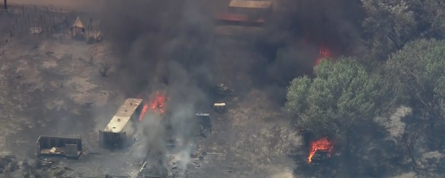
The Bain Fire expanded quickly within hours of ignition, prompting concern among residents and emergency officials. Strong winds and low humidity helped push flames across brush filled terrain, increasing the threat to nearby communities. Firefighters worked aggressively to establish containment lines while aircraft conducted water and retardant drops over active fire zones.
Officials noted that the fire behavior remained unpredictable during several periods of the response. Smoke from the incident became visible across surrounding parts of Riverside County, leading many residents to follow emergency alerts and evacuation advisories throughout the day.
Evacuation Warnings and Public Safety
⚠️ Wildfire Safety Tips
- Keep emergency bags ready at all times
- Follow official evacuation alerts immediately
- Avoid driving near active fire zones
- Close windows to reduce smoke exposure
- Monitor verified emergency updates regularly
Local authorities issued evacuation warnings for selected areas near the fire perimeter as a precautionary measure. Residents were advised to remain alert and prepare emergency supplies in case conditions worsened. Law enforcement officers assisted with traffic control while emergency crews moved equipment into threatened zones.
Officials encouraged the public to avoid unnecessary travel near active fire areas to allow emergency vehicles easier access. Community centers and emergency shelters were placed on standby in case evacuations expanded. Public safety agencies also reminded residents to monitor verified updates rather than relying on unconfirmed social media reports.
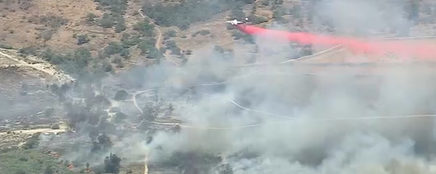
Firefighters Continue Containment Operations
Fire crews from CAL FIRE, Riverside County agencies, and mutual aid departments continued battling the Bain Fire throughout the day and night. Ground crews focused on protecting structures while air operations targeted hotspots in difficult terrain. Bulldozers and hand crews worked to strengthen containment lines around the most active sections of the fire.
Officials stated that changing wind conditions created additional challenges for firefighters attempting to stop the spread. Despite difficult conditions, emergency responders managed to prevent several threatened areas from experiencing direct structural damage during the latest operational period.
Air Quality Concerns Across the Region
Smoke generated by the Bain Fire created air quality concerns across parts of Riverside County and neighboring communities. Health officials advised sensitive groups including children, older adults, and individuals with respiratory conditions to limit outdoor activity while smoke remained visible.
Drivers also encountered reduced visibility near some roadways because of drifting smoke conditions. Emergency management agencies encouraged residents to keep windows closed and use indoor air filtration if available. Schools and outdoor event organizers in nearby areas continued monitoring local air quality advisories as the wildfire response remained active through the region.
Weather Conditions Complicate Fire Response
Southern California weather conditions played a major role in the development of the Bain Fire. Forecasters noted that dry vegetation combined with gusty winds increased wildfire risk throughout the area. Temperatures remained elevated during firefighting operations, adding physical strain on emergency crews working long hours in challenging terrain.
Officials warned that sudden wind shifts could change fire direction quickly, making containment more difficult. Weather experts continue monitoring conditions closely because even minor increases in wind speed could potentially influence fire behavior and the movement of smoke across nearby communities.
Community Response and Emergency Support
Residents across Riverside County responded quickly as updates about the Bain Fire spread online and through emergency alert systems. Community members shared evacuation resources, shelter information, and safety guidance while local organizations prepared assistance for affected families if needed.
Volunteers and support teams coordinated supplies including water, food, and protective masks for emergency personnel and displaced residents. Social media platforms also became a major source of real time updates, though officials reminded the public to rely on verified emergency agencies for accurate information regarding evacuation zones and containment progress during the wildfire incident.
Current Status of the Bain Fire
As of the latest available update, firefighters continue working to improve containment around the Bain Fire while monitoring hotspots and flare up risks. Officials have not yet released final damage assessments because crews remain focused on suppression operations and public safety.
Some evacuation warnings may remain active until weather conditions improve and containment lines are strengthened further. Investigators are also expected to begin examining the fire’s cause once crews secure the affected areas. Emergency officials continue urging residents to stay informed through official updates as conditions may change rapidly during ongoing firefighting efforts.
📌 Bain Fire Quick Facts
| Category |
Details |
| Fire Name |
Bain Fire |
| Area |
Riverside County, California |
| Main Risk |
Rapid fire spread due to wind and dry brush |
| Emergency Response |
Ground crews, helicopters, air tankers |
Conclusion
The Bain Fire has highlighted the ongoing wildfire dangers facing Southern California during periods of dry weather and elevated fire risk. Emergency responders continue working under difficult conditions to protect lives, homes, and surrounding communities near Riverside County. While containment efforts have shown progress, authorities remain cautious because changing weather conditions could still affect fire activity.
Residents are being encouraged to stay prepared, follow official evacuation guidance, and monitor trusted emergency sources for the latest developments. The coming days will likely determine how quickly firefighters can fully contain the Bain Fire and reduce the threat to nearby areas.
For more latest news, in-depth stories, and trending insights from around the world, keep visiting WikiWala and stay connected to what truly matters every day.
Disclaimer
This article is based on publicly available reports and emergency updates available at the time of writing. Wildfire conditions can change rapidly, and official information may be updated frequently. Readers should follow verified local authorities and emergency agencies for the latest evacuation notices, safety alerts, and containment information.
Sources

.webp)